
Monday, September 16, 2013
Muudy road to Zero Gravity
Sunday, September 15, 2013
Gorgeous drive

Individuals who have received this information in error or are not authorized to receive it must promptly return or dispose of the information and notify the sender. Those individuals are hereby notified that they are strictly prohibited from reviewing, forwarding, printing, copying, distributing or using this information in any way.
On our way!


We should have seen IT coming...
After waiting 20 mins for the once-every-10 minute shuttle the driver drove right past us (the only other humans in the entire parking garage) and parked 97 feet ahead of us at the small sign on a column. He opened the door...and sat on his ass and watched us move and load our gear.
I'm still incredulous to what happened next and blinded by rage but it went down something like this:
Me: "Hi we are here for our vehicles. Sorry for the duplicate reservations but we'd like two of the four seven passenger SUVs we rented and confirmed (via phone last week) would be available when we got here."
Car Rental Tool: "Sorry we don't have any. I can give you 2 sedans."
"Dude: look out the window at 12 duffel bags and 6 people..."
It was all down hill from there...
Anyway: we huddled and formulated and scrambled and an hour later were divided into 3 vehicles (2 Tahoes and a sedan) and headed to our hotel in Provo/Orem about 45 miles outside of SLC.
Craig and Phil were on Grub Master Duty and hit Super Walmart. The rest of the guys unloaded went to bed around 12:30. AM. C & P finally got to bed at 1:45 and crashed.
6:30 came fast. We enjoyed the hot-breakfast-included buffet and were on the road by 7:15.
We are on our way to Robbers Roost for 3 nights of back-country, off-the-grid car camping and canyons. We're going to try to hit Zero Gravity on the way and will keep you posted.
Individuals who have received this information in error or are not authorized to receive it must promptly return or dispose of the information and notify the sender. Those individuals are hereby notified that they are strictly prohibited from reviewing, forwarding, printing, copying, distributing or using this information in any way.

Saturday, September 14, 2013

Gear loaded for trip


Five people, 10 bags, 50 lbs each, 5 carry on backpacks and a couple of laptops.

Wednesday, June 05, 2013
B17 Bomber Flight
By Shawn McKee
Video from the flight here
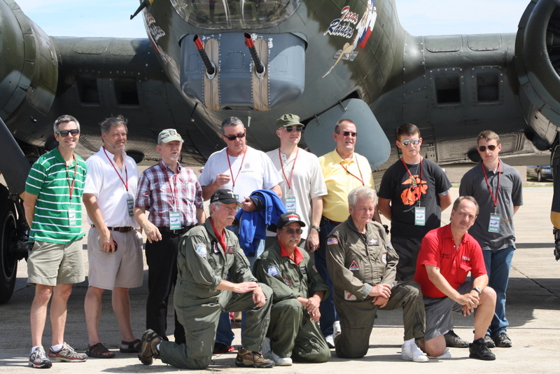
On Sunday I got to take a ride on a real B-17 bomber. Since my trip to Germany to visit the WW2 crash site where my uncle Raymond's plane crashed during a bombing mission in WWII, I have wanted to see one of these plane close up. Wow, what an experience. It's a living museum. Completely original in every way except that the engines continue to be overhauled every 1000 hours. The flight is made possibly by a very crafty group of volunteers and pilots from the Commemorative Air Force organization, or CAF. This group came over from Texas to show the flying relic of world war two.
More info on this particular plane can be found here http://gulfcoastwing.org/trhistory.html

I enjoyed every minute of the experience. With open windows, original equipment on the plane, and wooden seats to strap into, it was amazing. The smooth gracefulness of the take-off at only 110 mph is right in step with impressions of those days in 1945. Hard hand crafted metal mechanical stuff all over the plane display the utilitarian nature of this plane. There were also some very sophisticated bombing sights and electric motor driven gun turrets that would have been state of the art in the day. Still impressive today.

I have to admit it was historic and emotional to see the plane taxi up to the line, but after lifting off and sticking my head out the window like a 2 year-old Labrador Retriever, I was just having fun. Cruising over New Orleans on a mock bombing run at 1500 feet, so slow you could watch people on the street and see them looking up at you, it's easy to imagine dropping heavy things on buildings from that deck. Not as easy to imagine fighter planes buzzing around though. Every part of that old plane was built for lifting, durability, and viewing the ground. What a classic airship. One that will never be needed again. I can see how the crews became attached to their planes.

"Don't lean too far out the windows. There is a little suction that will steal your cap, sunglasses, toupees." we were told in the pre-flight instruction. We also were warned not to grab the silver cables running through the top of the cabin. "We use these to fly the plane." Indeed, you could watch the rudders and elevator being controlled by these cables just over your head.
An amazing flying piece of history. And what a great way to see the Crescent City.
Here is the actual flight path as recorded by my run app on my phone.

Video from the flight here
On Sunday I got to take a ride on a real B-17 bomber. Since my trip to Germany to visit the WW2 crash site where my uncle Raymond's plane crashed during a bombing mission in WWII, I have wanted to see one of these plane close up. Wow, what an experience. It's a living museum. Completely original in every way except that the engines continue to be overhauled every 1000 hours. The flight is made possibly by a very crafty group of volunteers and pilots from the Commemorative Air Force organization, or CAF. This group came over from Texas to show the flying relic of world war two.
More info on this particular plane can be found here http://gulfcoastwing.org/trhistory.html
I enjoyed every minute of the experience. With open windows, original equipment on the plane, and wooden seats to strap into, it was amazing. The smooth gracefulness of the take-off at only 110 mph is right in step with impressions of those days in 1945. Hard hand crafted metal mechanical stuff all over the plane display the utilitarian nature of this plane. There were also some very sophisticated bombing sights and electric motor driven gun turrets that would have been state of the art in the day. Still impressive today.

An amazing flying piece of history. And what a great way to see the Crescent City.
Here is the actual flight path as recorded by my run app on my phone.
Shawn
Sunday, October 30, 2011
Tick-Fall Color PWC Tour
Billy Crews & Cody Reulet
Trip Report by Billy Crews
Trip Report by Billy Crews


 Too many drop-dead, gorgeous Fall days had already passed me and I told myself not to let the next one slip by. Keeping my word to myself, I was intent on visiting the Tickfaw River watershed on the last Sunday in October. Joining me, yet again, was Cody Reulet, whom always seems ready for a little adventure. Today would be no different as our goal was to take in the Fall colors while putting the bikes on water-ways neither of us had yet traveled.
 |
| Tin Lizzy's Landing |
Launching out of the Tickfaw Marina, we idled around the corner from Tin Lizzy's Landing, under the Hwy 22 Bridge and made the first leg of the day's run up the Tickfaw for as far as we were comfortable. Cody let me take the point while he fell in on the starboard wing-man position. We put about eight miles between us and the bridge - a distance far enough upstream where the river is not much more than a small bayou with several hairpin curves. I made up my mind that this was absolutely the best time of the year to make this run as the smallest amount of boat traffic could easily turn a good day bad in just one turn.
 |
| The Warsaw Marina |
 Moving on, we continued up the Blood to the first split and took the left fork which is Lizard Creek. Navigating Lizard Creek is like being in two places at one time: The left bank is a typical SoLA swamp scene with a majority of the timber being cypress and tupelo. The right bank, however, is predominantly pine forest. We made the Lizard Creek run for nearly two miles until we hit the Blood River Rd. Bridge. Turning around, we back-tracked to the Blood River and then made the run for it's upper reaches.
 |
| Nearing the Carter Plantation property |
Like the Tickfaw, the Blood River doesn't take long to narrow into a very curvy bayou. Travel far enough, it gets smaller, resembling a deep slough. Go further and your in not much more than a ditch. We finally got "inside" the Carter Plantation development and ran the water-way as far as the 2nd crossing of the Blood River Rd. Looking past the bridge, we noticed the bayou was full of downed trees and no longer navigable. Cody, turning around first, took the point back and as far as the Lizard Creek Branch.
 |
| Tickfaw BooPaLu's |
Heading back down river, we stopped just past the Hwy 22 Bridge at a newly opened riverside establishment, Tickfaw BooPaLu's. Cody evened up the expenses by buying the next round and we soon discovered that the Rams had extended their lead by yet another touchdown. Ouch! Let's go ride...
Cruising down the Tickfaw we were both on familiar territory: Cody had ran this stretch back a summer or two ago, while I had my time here back during the Regain administration... Seven miles later we finally reached L. Maurepas and both noted that it'd been a great day to be on the lake. The sky was blue, the air was near 70 degrees, and the lake was mostly flat. We had one more goal for the day though so back upriver we went to go check out the Natalbany River.

Just past the Prop Stop, we made a right turn into the Natalbany's confluence with the Tickfaw and cruised due north in search of Ponchatoula Creek. Neither of us had been up here and I wanted to mark where the P. Creek hits the N. River. We found Ponchatoula Creek just less than four miles later and we made plans to wait for warmer weather to investigate both it and the upper Natalbany near Springfield.
Making our final turn-around and double-back for the day, we blasted back up the Tickfaw. I pegged the throttle for a quarter mile on the way back and found good numbers, both on the cluster and GPS. (66.9 @ 8160). I guessed Cody was only at three-quarter throttle as I knew his bike was modded for speed. He was a good sport though and never tried to overtake me.

We made the marina in no time and upon arrival we both commented how nice it was to have had the water to ourselves on such a fine day. The bonus, of course, was having Mother Nature display her full compliment of colors. Perfect though? Hardly - the Saints lost to the Rams...

Wednesday, June 08, 2011
(Not So) Deadliest Catch
Billy Crews and Mike Gautreau
(Trip Report by Billy Crews)
(Trip Report by Billy Crews)
DAY 1
The plan was simple enough: Day 1 - Leave the office a few hours early, pick up Mike, load up his party barge with crab traps, bait, and a few beers, then drop the traps in the water near the mouth of Blind River. Day 2 - Pick up traps and (hopefully) enjoy an evening crab boil. There was no plan for the darkness that came in between the two days...

Our expenses for Day 1, which included the fuel, bait, and beer would total near $75.00, so we were hoping to catch $35.00 worth of crabs. Loaded up, we left Matt's (Mike's brother) safe harbor in their co-owned, partially homemade party barge and sipped on a few as we cruised the Diversion Canal towards Blind River. I worked on baiting the traps as Mike navigated the water and cranked out a few tunes. We had heard reports of crabs showing up in the river, so our plans was to drop a full compliment just on the down river side of lower Alligator Bayou. Mike idled the bank as I dropped each trap every 30 yards or so. Once they were all in, we verified they were lined up with each float marking the location.


Neither one of us paid attention to the route as we headed back up river and we unknowingly passed up our cache of traps. As the weather was very close to threatening, Mike was ready to keep heading in, but I managed to convince him of otherwise... (not a smart move on my part). By the time we reached the first trap we could hear a little rumbling a few miles out. By the time I checked the second trap we started seeing a few fireworks in the sky. At the third trap I realized my mistake and that all hell was about to break loose...
 I dropped the last trap, noting that each had one or two crabs, but none that were size worthy. Mike made an abrupt U turn and up-river we went. The party barge gave us all she was worth, but in the end we would fall six miles short of our goal. We sprinted along the river as the sky hurled down bolts of
lightning over and around us. Blowing through the NWZ at the Blind River Bar, we would only manage another half of a mile before meeting with a wall of water. Right before the rain hit, Mike spotted a boat house on the south bank which ended up being the only shelter in a one mile stretch. Easing her in, we lashed the barge to the pilings and then made a quick survey of our situation: Fuel - check, battery juice - check, beer - uh-oh, we have a problem. Although we were secure shelter-wise, we had managed to exhaust our compliment of six beers for the trip. It was now just past 8:PM and for the next hour and a half, Mike and I sat back on a covered patio swing and watched Mother Nature display her wrath.

We would make a few phone calls and texts as the evening went on; we wanted our families and friends to know we were OK and out of any immediate danger. We even sent a few texts requesting aid in the form of beer, but none came. By 9:30PM, even though the rain and wind has subsided, there was still a pretty good show in the sky going on. We verified by phone that the radar indeed showed a break in the storm cell, but another was lined up right behind it and heading our way (which explained all the lighting still coming our way). Before leaving, Mike managed to get a burner hooked up to a propane bottle going (provided by our unknown host) and we each took turns warming up and drying our clothes. A little drier and a little warmer, we gambled on the tidbit of radar beta and, based on our own observation, decided to make a run for home.

Although it was pitch dark, the home sites along the Diversion lit up the bank while the night sky would give us a bright picture of what lay ahead every thirty or so seconds. Although we ran down the canal as fast as possible, we played it safe by each wearing a life-jacket. We finally arrived at Matt's house around 10:PM. After lifting the barge out of the water, Mike and I headed home with us each getting in around 10:30PM.
Here's a little running in the weather vid: http://www.youtube.com/watch?v=vuRNPovjQ0w
Day 2
 With a good night's rest followed by most of the day spent working; Mike and I headed back out on the Blind to retrieve the traps. Being it was Wednesday, we were greeted by nearly three dozen bass boats as they blasted their way to their individual fishing spots, all competing in the Canal Bank Wednesday Night Bass Tournament.
The weather was as near perfect as could be for June in SoLA and we both enjoyed being out of doors as compared to the evening before. We found our traps in no time and Mike did a perfect job of lining up the barge as I hauled in the catch. Except for one empty trap, we averaged three crabs per pick up with most being no. 2 in size and a handful of no. 1's.
 With time and good weather to spare, we decided on navigating the entire length of Alligator Bayou. I had not been down the bayou myself in over a quarter of a century, and nothing seemed familiar as we made our way north. The bayou water was dark and glassy, and we had it all to ourselves until the very end. Mike took his time cruising the smaller water-way and I occupied myself taking the occasional picture of the postcard-like scenery.

DAY 2.5
A picture is not worth a thousand taste buds...

Wednesday, June 01, 2011
Two for the Road
Billy Crews and Shawn McKee
(The following are the post-BNR 2011 emails regarding this year's trip.) As Shawn and Billy were the only ones to make the pilgrimage this year, one is inclined to inquire: Where the hell was everyone?!?

BUFFALO REPORT TO CORE COMMITTEE:
Ok, it was tough not having you two with us this year on the Buffalo. We did honor the core and place another year in the books. When we finally realized that we weren't going to find royster at Kyles with a hugh compound, something cooking, and smoking a cigar, we resigned to the fact that no one had reserved us a site the night before. So we left Kyles and talked to a ranger. Steel creek full, Ozark full, Lost Valley closed, we headed to Erbie. The road was fixed that week, best its ever been. The sites were freshly bush hogged and raked, private, enclosed by bamboo that had been under 15 feet of water the week before. Found a great spot, set up camp. Once I realized that the good beer was disappearing from the cooler at the exact rate that I was drinking the good beer, then and only then did we relax and decide we really did not need you two to get us through the buffalo trip this year.
We did miss y'all on the river. Billy's not much into frisbie. And I forgot to put ice in the cooler on the second day - had to bum it from a nice couple on the river. But we survived.
So, here's the report. Bill can annotate.
1. water was perfect. 18 inches on Saturday, probably 22 on Sunday. Lots of class 3, haystacks, logs, debris from the big flood.
2. fishing was good to very good, I would say. I enjoyed it. Lots of current and places to gather the food
3. people generally behaved. Lots and lots on saturday, one tenth as many on Sunday. Lots of kayaks, rafts.

4. Erbie is a fine campground. I don't know why the outfitters hate it. The road is better and quicker than kyles. Spots are great. Close to Jasper. Will do that again.
5. We did double shuttle because of one car. This works fine. No problems. Did not walk more than fifty feet either day.
6. Nalgene of Sierra Nevada Pale on Sat, Sam Adams Cream Stout on Sunday. Good west/east mix for the menu. (along with a few of Billy's GD 64s)
7. Lost Valley Canoe is now fully run by siblings of Larry and Jo. Jo retired, Larry is a bad topic. Chris and Brian, Larry's brother, alone with Emily and Bret do a fine job. First class.
8. Great meals this year including full breakfast every morning, full dinner every night, specialty coffee on the way to the boats. Excellent and cheap and fast and easy. ((ozark cafe))
9. Roy's cabin was awesome. Just can't say enough about it. Perfect. Great way to conclude the trip.
10. Interstate barbecue and Roy's hamburgers with Johnie and Jace bracketed the travel. Really enjoyed visiting with you guys.
There you have it. We decided, without quorum, that the water should determine the upper/lower thing every year. Like all the unpredictability of the Buffalo that we love, the water is the ultimate guide. Going to the upper was so perfect this year that it can not be missed. But in low water going do to Rush is the answer, staying on the river. Staying at Roy's on the final night is perfect.
ps. crown royal and pink floyd and 3am is a tradition. -Shawn
Haha, nice report. Glad to see you kept up the all night Floyd vigil. Good stuff! -Andy
 Excellent summary! There is nothing to add to the BNR part of the experience, but, I will say that the effects of the Great Flood of 2011 are far reaching and still viewable. The flood waters in the delta I expected; the amount of standing water that has been pushed up and is still surrounding Little Rock was quite a shock. 'nuff said.
(I suppose I'll expand upon Shawn's treatment and SC blog it w/pix...)
PS: I've concluded the following: It's not Devil's Walking Stick (which is a small, ornamental tree) or "Fire Weed" (which is a perennial herb/flower that propagates really well in the wake of a forest fire). It's Stinging Nettles: Ouch, they burn. I'm curious - I'm suffering from an allergy attack that started late Sunday afternoon, which is usually symptomatic of histamines being released in excess in the body. I got branded by Stinging Nettles on Sunday afternoon, and part of my research found that part of the toxins released by the plant are histamines. Hmm, any opinions on the relationship...?
I always thought it was fire weed. Maybe that's the local mary jane and poison ivy mixture.

we found a cave. It goes, but not on this trip. -Shawn

Anytime bud. I just wish I could have joined you guys. Maybe next year.
-Andy
Guys,
It's good to know I was missed. Can't think how many mornings I've been
asked one or both of the following on the river:
McKee: Dale, are you getting coolers together? Oh, yeah, you're already on it.
McKee: Dale, are we taking nalgenes? Oh, yeah.... uh, how many you got? Okay, I think I can find some more over here somewhere...
(Mac, sorry good beer had to disappear from the cooler on a one-to-one ratio. My bad.)
I only beered up one nalgene this weekend, but I discovered how to carry it to the pool on my bike (it hangs on my gps bracket--glad I finally found a use for that thing), so the weekend wasn't totally wasted.
Still, missed being there with you guys. Although I know y'all had a great trip, just the two of you and 9,000 other people on the river on Saturday.
Hey, did y'all canoe "Ponca" to Pruitt? Or do "Ponca" to Kyle's twice? Did you catch up with the Andrewses at the cabin, or in L.R.?
P.S. Roy, I really missed seeing you (and the family)--not those guys, since I'm gonna be stuck with McKee and Crews for a week in a couple of months. -Dale

Steel Creek to Kyle's (NPS won't let the outfitters launch at Ponca on that weekend), then Kyle's to Pruitt. And we invaded the Andrews' at their "hangar" in Li'l Rock. -Billy
Billy,
Thanks. I knew about Steel Creek (I just couldn't think of its name)--that's why I put "Ponca" in quotes. Billy, had you ever met Roy's crazy Portuguese dog before? I think he and Brian Pope are related. -Dale

yes! that slide was impressive. Yosemite-ish. It will be a clear hillside for the next 20 years. Very efficient tree and land removal. The new slabs of rock in the river slipped silently beneath our canoe looking no different from the other slabs except for their fresh clean virgin rock faces minted from formally solid cliff. New sunlight will cultivate that section of river into something unlike the dark passage it was before. We were told it happened within the last week. The locals seem impressed also. It actually closed the river for a few days. -Shawn
Wow! Glad you didn't see it too, Billy. Did y'all take a photo? Do you think it dammed/backed up the river pretty good before the new channel was cut? -Dale
 Thats because we shaved him Dale LOL. -Andy

Billy,
Thanks. I knew about Steel Creek (I just couldn't think of its name)--that's why I put "Ponca" in quotes. Billy, had you ever met Roy's crazy Portuguese dog before? I think he and Brian Pope are related. -Dale

Well, I met some kind of dog while visiting the L'il Rock gang, but he didn't look like Pope.
BTW, the river got a little smaller just below the Steel Creek launch: Last weeks torrential rain and flash flood caused an "enormous" landslide on the south-side bluff. I estimate that the debris field came from approx. 200 feet overhead and looked to be about half of an acre in surface area. The pile along and in the river was unbelievable. Trees that were a foot thick near their base were snapped like toothpicks. I wish I could have been there to see it, but was glad I wasn't... -Billy
yes! that slide was impressive. Yosemite-ish. It will be a clear hillside for the next 20 years. Very efficient tree and land removal. The new slabs of rock in the river slipped silently beneath our canoe looking no different from the other slabs except for their fresh clean virgin rock faces minted from formally solid cliff. New sunlight will cultivate that section of river into something unlike the dark passage it was before. We were told it happened within the last week. The locals seem impressed also. It actually closed the river for a few days. -Shawn
Wow! Glad you didn't see it too, Billy. Did y'all take a photo? Do you think it dammed/backed up the river pretty good before the new channel was cut? -Dale
No, I purposely didn't take a pic (knowing I should have anyway), b/c the beginning to end "event field" was too large, and we were up close and personal w/it. My pix would have done it no justice, turning an act of God into a ho-hum event. You would have to see it to be impressed. But I don't think it totally blocked the river; I seem to recall the new obstacles staying pretty much to the south side of the river.
But have no fear - the results from the event will be lasting for years to come. -Billy
 Thats because we shaved him Dale LOL. -Andy
BTW... Shawn, would you please extrapolate the following data (you gotta know where to look, brother...). We concluded that Saturday, 05/28/2011, equated to: Damn perfect! (My guess is 18 inches of air at Ponca.) -Billy

I would concur with their red line 2.5 ft equals 24 inches of airspace. I might set the bar a little lower at maybe 28 inches as the cut off but this could certainly be used. The drop rate for that river is pretty constant, I imagine, from storm to storm.
If we had looked at this on midnight the night before driving up may 26 we would see 3.5 feet of water. But, even the next day would have been good canoeing if we had done Sunday and Monday, so the real indicator is 3.0 feet of water.
Rule: If you look at this gage at midnight on Thursday night and you have 3.0 or better, you call Roy and tell him to head for Kyle's Landing. If below 3.0 you call Roy and tell him to pick up steaks for the cabin. (canoe the lower). -Shawn
Saturday, April 30, 2011
In Search of Little Florida
Billy Crews & Samuel Babin
Trip Report by Billy Crews
With the Mudbug (MB) date closing in, I figured it was time for me to do a little pre-routing. Although I had posted four trips for my MB PWC tours to the forum, I was not actually familiar with every mile of water. My spillway ride in particualr, the one that circumnavigates Flat Lake, actually includes a few miles of water I’ve never navigated, while the rest I rarely visit at all.
Riding with me today would be fellow PWC enthusiasts Samuel Babin from Denham Springs, LA. Samuel had called me earlier in the week inquiring about making a ride soon. I immediately concluded he’d been lurking around the forum and had come across my post regarding my plans to ride today. I was grateful for the call and was glad to have a wing-man. Samuel and I had crossed wakes before nearly two years ago on a group ride along the Amite system. Quite the experienced rider, Samuel had the pleasure, and guts, of completing the Eastern Leg of the Great Loop. Laying down approximately 1,000 miles in 23 days is no easy task, so I welcome that much experience to join me anytime I’m on the water.
Samuel met me at my house in Duck Roost and then followed me down to the camp in Belle River so I could pick up the bikes. With the trailer hooked up, we finished our route down Hwy 70 ending at the Joe Russo ramp which accesses the Spillway at Flat Lake. With the river topping five feet on the Morgan City gauge, the water was up and we both had to wade out to unload the skis. With the skis dropped, we both commented about how the weatherman got it wrong again: It was not warm, clear and sunny; instead, it was windy, chilly, and the sun couldn't be found.

Idling out the launch facility I described our route to Samuel which was basically a loop around Flat Lake with a little extra mileage on the north end of the route. We throttled the bikes up and cruised north in the ICW for a few miles and finally ducked into the bottom end of Bayou Sorrel. The Spillway really shows itself here: Within 300 yards of entering the bayou, the water color went from a muddy caramel to coffee black; large, second growth cypress, along with willows and tupelo lined the banks. We carved up By. Sorrel a few miles until we reached Big Fork Bayou whereupon we turned north and entered the “extra mileage” portion of today’s ride. Big Fork bayou is easy enough to navigate even to the untrained eye, but upon crossing the Thirty Inch canal I had to consult with my 76. No sooner than I spotted my track on the unit I was able to see it clearly enough as I remembered it. Between the Sixteen Inch canal and the Thirty, Big Fork has hardly any trees to define the curves of the bayou. In an area where the swamp basically opens up, you have to know where the bayou runs or you’ll find yourself in trouble.
We crossed the Sixteen and continued up Big Fork serpenting our way north towards the Twenty-One Inch canal. In between the Sixteen and the Twenty-One, Big Fork becomes a little narrower with countless cuts and sloughs lining each side of the waterway. Having never been in the Spillway before, I was fairly certain that Samuel was pretty much lost five miles back. He would glance over at me every so often with a “which way?” look and I respond back with either a nod of the head or a wave of a hand to indicate the direction. We were just over twenty miles into our track when we reached the Twenty-One Inch. Cutting back to idle, and turning westward into the canal, I explained to Samuel that this was as far north that our track would take us and were going navigate our way back south via yet another route.
We headed down the Twenty-One, single file, with Samuel on my six. Remembering last summer’s grass problem, I was hoping SoLA had had enough of a winter to damage the crop, but that didn’t happen. Standing on the ski, I travelled the glassy, black water just a foot or so above the coon-tail grass that was reaching up from the bottom. This was no good - and it would only get worse the further I’d go. I motioned to Samuel that I was stopping and turning around. I think he was a little confused on why the route was coming to a stop, or at least until he realized how much grass we had navigated. Heading back the way we came felt a little sinful: There is just something wrong about having to run over the same patch of water twice. I was hoping to get to Misty Crew bayou, but that just wasn’t going to happen today. And it obviously won’t be happening anytime this year. The grass will only get worse as the water warms up.
 We back tracked up to the point of the Sixteen Inch where upon I told Samuel perhaps we could bushwhack another trail over to Misty Crew. I had spent more than my share of days skipping school to know that there was more than one way around that section of the Spillway, but that had been nearly thirty years ago, too. I reasoned that we could keep on down the Sixteen and then take the Thirty over to Misty Crew. But that wasn’t going to happen either - we found the Thirty about a mile further, but it was blocked by a lily jam that had no end in sight. Realizing there would be no alternative routes travelled by PWC today, I finally gave in to mother nature and retreated all the way back to Bayou Sorrel. Upon reaching Sorrel we made a right turn and began the actual route which circumnavigates Flat Lake. Heading due west, we passed the “months of the year” bayous: June, May, April, and March. The next bayou was Misty Crew and I slowed up to explain to Samuel that this is the Bayou we should have been coming out of as opposed to passing by it. Oh well.... Looking down, I noticed that the bayou was begging to lose it’s black color, reverting back to shades of caramel. You can always tell when your nearing a major body of water in the Spillway - the water color lets you know all the time.
We finally made American Pass and I felt like I was finally entering uncharted waters. My regular riding buddy, GL, had attempted this route via his party barge earlier in the year, but the water proved to be too low and he had to turn around. We put about a mile of the pass behind us whereupon the banks began closing in. Also, showing up in the waters were reeds and various other plants that grow out of the water; all signs of shallow water. We finally made the island that has taken over the once wide American Pass and you could just discern a line in the water: Undoubtedly there was a shelf of shallow water straight ahead. We eased into the shallows and after a few hundred yards, I pulled out my rope and anchor to do a depth test. Six feet - not bad, but I didn’t want any less. Having second thoughts, I raised GL on the cell and we discussed the situation. He reminded me that the gauge in Morgan City was two feet higher than when he attempted it, plus, American Pass was full of silt from the main river which means it has a hard bottom. I consulted the anchor again and it sunk fast to six feet and hit hard. I tried to drag it but it wouldn’t grab in the hard sandy bottom - yeah, GL was right: We could walk out of here if we had to.

Pressing on, I made three more drops: Five feet, then four feet. Damn, the rope was getting short in the water. But we could see the river just a few hundreds yards further and gave the bikes a low throttle forward. My third and final drop registered over six feet: We were over the hump! Passing out of American Pass, we made a northward turn into the very wide and quick moving Atchafalaya River. As the day was windy, the river was white capping, but the waves were low and not at all uncomfortable. We navigated just over a mile and finally reaching the north point of Little Island we beached the bikes in the shallow waters of Little Florida. During the spring rise, most of Little Florida, as the huge sandbar is known, is under water, but the bottom was hard and smooth and was quite easy to walk around. Samuel and I both took a well needed bladder break then mounted the bikes to finish up the route.
 Running down the south side of Little Island I was reminded of the Mississippi River on the B2B run: The current was fast and full of debris. There were also many currents with some converging and causing rip lines with white caps. We stayed in the main river as we skirted the south west side of Flat Lake and in no time had made the confluence of the Atchafalaya and the ICW. Turning south in the main channel, Samuel followed me to the few way-points that I had plotted as Points of Interests for this year’s MB. Our first POI was the “Mr. Charlie” rig, home of the International Petroleum Museum & Exposition. We did a slow fly by getting a good look at the antique oil extracting facility. Next was the city wharf at the sea wall in Morgan City. There were a few folks fishing off the dock, nestled in between the shrimp boats that were moored there.
 Heading back towards the ramp, we slowed up at the nearby Coast Guard mooring facility. While I can’t exactly say what types of ships they keep here -small cutters? - the guns mounted on the forward decks, although under wraps, were impressive enough. We finally reached the south end of Flat Lake and took the right branch, which becomes the ICW on the eastern side of the Spillway. I slowed up just long enough to capture a few pix of Flat Lake and moving on, we had our bikes back on their trailers at the Russo boat ramp within a few minutes. Although the route I wanted to take turned out to be a wash, I got to make a good run over some old grounds, lay down a new track, and spend the day in good company. Thanks, again, Sam - I had a great time.

Subscribe to:
Posts (Atom)