March 18, 2011
Billy Crews, Cody Reulet, Shawn McKee
by Billy Crews with special commentary by Shawn Mckee
So it only took me three years of planning and talking about this ride to “get ‘er done”. My Belle River buddy, GL Legendre, Jr., and I had tried once before, but that didn’t quite work out for us. As it turns out, the second time was the charm.

The B2B, as I call it, is a proposed, single day, PWC trip from the Blind River area, (near my home in Ascension Parish) through the connecting water-ways of SoLA, to my family camp on Belle River (Assumption Parish). Through my work via Garmin’s MapSource, Google Earth, and my own personal knowledge of some of the water we would be traveling, I estimated the trip to be 225 miles. Our route would indeed come close with a final tally of 223 miles.
In layman terms, Billy is trying to travel by water from the east side of the mighty Mississippi River, beginning just south of Baton Rouge, to the west side of the Mississippi, but ending further south than the starting point. The ride is an ugly “horseshoe” shaped route the would cover 200 miles of bayous, lakes, rivers, bogs, swamps, marshes, and man made shipping canals. The starting and ending point would be about thirty miles as the crow flies from each other, or about forty-five miles by car. I’m from Baton Rouge and I still could not understand how it could be done except for the fact that the whole southern part of the state is in naturally standing water. Even after studying Billy’s careful plans and google earth maps, I still envisioned us having to use a long pole to push through gator infested and soupy ditches of floating goop. Man was I wrong. -Shawn
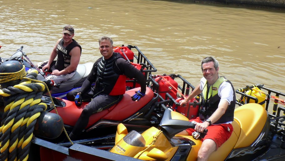
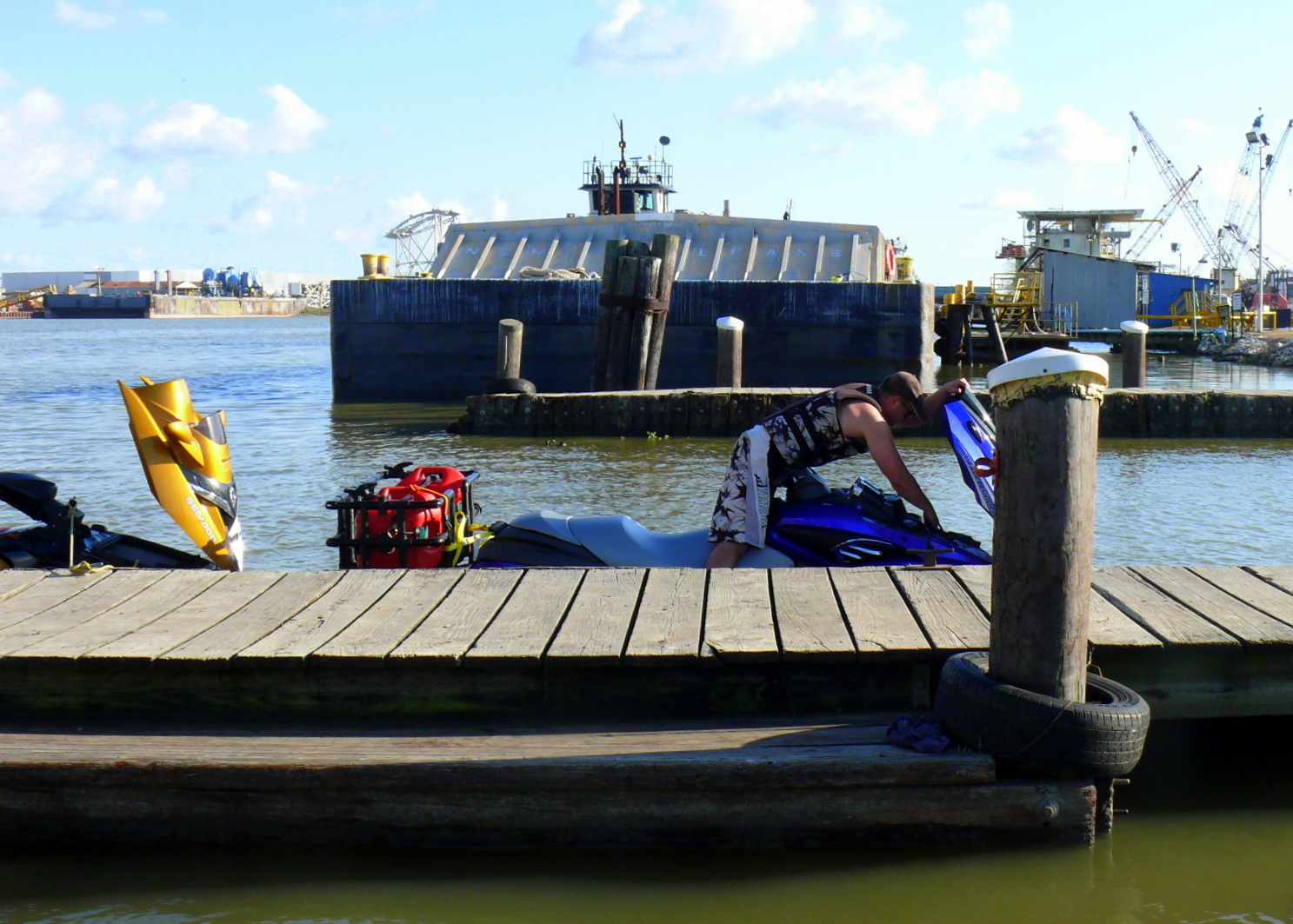
Joining me would be my lifelong friend and SoCan extraordinaire Shawn McKee, and Cody Reulet, a fellow Green Hulk forum member and regular LaConn PWC rider. Mac had come in and found my living room sometime around 2:AM, just four hours before zero hour. Flying in from the family ski trip in Salt Lake City, UT, he had just got home in Jackson, MS at 9:PM that same night. He pretty much got home from the airport, got the family inside, and traded ski luggage for his prepacked wetsuit and other gear. Cody would arrive in the driveway at 06:30, where he’d left his ski the night before.
I was hoping to cheat sun-up by departing at 6:45, but a heavy fog, and a little issue with Cody’s truck at the ramp delayed us. Not paying attention, I didn’t stop Cody in time from getting his rear truck tires on the algae covered, wooden ramp that the Laurel Ridge facility is despised for. Cody actually got his ski back on the trailer and literally “pushed” his truck up the ramp while I gassed the pedal and Shawn bounced up and down in the bed to help gain some traction. Having solved the stuck-truck problem, Cody and I shuttled our vehicles back to the house, while Shawn tended to the skis. My son, Trey, then ran us back to the ramp.
I must admit, I’ve never seen a jet ski push a pickup truck back up a boat ramp but that’s exactly what they did. I did what I was told, not knowing a thing about boats or trailers, and bounced up and down in the truck’s bed section. In my opinion, the truck was really stuck and not going to come off the slick boards without a tow, but they improvised and got us by our first obstacle with only a few minutes lost. The first “dick-move” (DM) of the day, however, was leaving me at the dock tending the skis - The place smelled terrible; eventually I realized that huge, dead, bloated fish were floating all around and staring up with zombie like eyes.
I’m sitting barefoot on my ski holding the dock with one hand while trying to keep the two other skis along side me with the other hand. The whole time I’m tending the skis I can hear unseen creatures yanking at the floating fish and taking them under or taking bites out of them. Turtles, please let them be turtles... -Shawn
We were finally underway, although forty-five minutes later than I had hoped, at 7:30AM. While the fog was thick, it was not totally unmanageable, offering nearly 150 feet of visibility and allowing us to travel at approximately thirty mph. I couldn’t see my companions in my rear-view mirrors but I could make out their shadows and spray if I looked over my shoulder.
While it’s hard to get ‘lost’ in a Louisiana bayou, it is possible to hit all sorts of things when you can only see a hundred feet or so in front of your ski, which is going thirty mph. I watched Billy’s boat wake spread out in front of me but I could not see him at all. The wake got wider and wider until I was only following a trail of bubbles down what I hoped was the center of a very windy, narrow ditch they call a bayou. Never is the land more than a foot or two above the water on either side and many times other canals and inlets appear on the left and right which confuse the route. I was leaning over the steering wheel in a futile attempt to possibly hear another boat coming so I could ditch my jet into the soft bank, if need be. From years of adventures with Billy, I knew he was nervous about this fog and I suspected he had forgotten completely that I was behind him. -Shawn
By the time I reached the first bridge on the Sevario Canal, Cody fell in place, while Shawn was just rounding the bend. When I made the second bridge, Cody was still there but Shawn had fallen back some more. By the time we made the pumping station at the New River Canal, Cody and I were both waiting on Shawn. After easing through the pumping station, I coached Shawn into picking up the pace, at which he replied “the ski won’t run”. Nonsense - these bikes are running at optimal performance, I thought. Picking up speed to make up for lost time, we travelled the five miles to where New River dumps into the Petite Amite and I told Cody to run ahead to Blind River, while I waited on Shawn. Mac had fallen at least half a mile back to which he again blamed on the ski not running.
By some luck, the speedometer on my ski was not working. Billy had told me this along with “Don’t suck up any grass into the pump and don’t over load my supercharger.” before leaving the dock that morning. The entire maintenance briefing had lasted fifteen seconds with no time for Q & A. So, with my last ski trip being over a year ago, I had no idea of how fast I was going, nor had I ever zoomed down curvy ditches in heavy fog. The ski would not give me more than 5200 RPMs and seemed to just sag when it got to that point; it felt like the water was made of glue. In fact, I rationalized that the early morning swamp was somehow thicker than the afternoon swamp. Yes, this must be why I can’t keep up with the other two skis - I just don’t have the Cajun training to ride “heavy swamp”. -Shawn
To convince him that he was wrong, we traded skis, but kept our own jackets and lanyards. By the time I reached the Blind, where Cody was waiting on us, Shawn had once again fallen another half of a mile back. When Shawn finally “arrived” we were about thirty seconds into a discussion regarding his ability to follow closely when I noticed he had the SeaDoo proprietary “Learner Key” connected to the DESS post. With that particular key, Shawn’s max speed was governed electronically at 5200 RPMs for about 30 mph.
Now I know Billy probably owes me a few DMs over the years, but this was a classic payback and the second DM of the day. There have been times when Billy has faithfully followed me down a rope, into a cave, or on some other adventure. Other times he takes me off into the swamp where only he knows the way back. We trade off expertises and trust each other completely. Today it was his turn to lead - I followed in full grunt mode. During the fifteen second briefing at the dock, I was told to use the “yellow key” which was in a plastic bag in the ski’s glove box. I quickly found the bag and the key marked “YEL”. This was the key I incorrectly used until later when we discovered that it was not the yellow key. In fact there are two keys marked “YEL” in the bag meaning they went with the YEL-low jet ski. They had no distinguishing color left, having faded long ago, but at one time one was actually yellow. If you know Billy, this is a classic DM. My hat’s off to him on this one. -Scared the shit out of me. -Shawn
With our second glitch for the day resolved, we were back to dealing with the fog as we cruised Blind R. up to it’s confluence with the Diversion Canal. We made a brief stop at the Blind R. bar so I could install fresh batteries in my 76; I had gotten a low battery signal and I knew there was no way we could navigate Lake Maurepas unaided.
We finally made the lake and without hesitation commenced to cross. We had only gotten about two miles off shore when the fog thickened to pea soup. I checked up to make sure we were all together and Cody declared I was headed in the wrong direction. I assured him I was on track and he needed to have a little faith in the electronics. We continued on and the surface went from a light chop to out right turbulence as we battled two to three foot seas completely concealed within the fog. The waves kept our speed to around twenty-five mph, and continually pushed us off our center line. Having to endure these elements for the next ten or so miles, we basically would push ahead for about 500 yards, then make a course correction to the starboard.


Cody, an experienced rider, managed to stay in the starboard wing-man position, but Shawn lagged behind, barely visible in the fog and waves. Although I feared losing Shawn in the fog (that would have been fun...), I figured he could still see me although I would be more of a shadow than a figure.
Now here is where I start to wake up and realize I’m in way over my head: I’m standing on the ski trying to time the waves so that the craft doesn’t ramp over the crest and send me into the back of the next wave. To do so would result in a face-plant on the handle bars. In full wave-battle mode, you bend your arms and legs as the damn machine has become like a bull jumping unpredictably up and down. “Riding the bull”, I’m trying not to let the bow jam dolphin- like back into the bottom of the next wave and send water over the front of the ski. All of the maneuvering is controlled by one flick of your right thumb: About one half inch of thumb throttle control takes you from zero to full power; either one of which will throw you off the ski. With my body standing and doing this hands forward, knee bending sort of techno dance, I find it nearly impossible to keep my thumb at the proper angle to manage the throttle. And one more thing: When the ski goes airborne, which is every 10 seconds in these waves, I have to completely let off the power before ramping out of the water to protect the engine’s supercharger from over-loading. You have to anticipate this going airborne thing. I’m concentrating the whole time, losing the battle to coax enough speed from the bull riding routine to keep up with the other two. Also, there is only one half second, every 6 seconds, where you go “zero G” and you can take your left hand off the bar to wipe your goggles. Mistime this hand release and both hands get yanked off, power goes to zero, and you crash into the console all chest or stomach - I did this several times. But, if you go three waves without wiping your goggles, then you completely lose visibility from the condensation of the heavy fog - then you must feel for the next “zerol G” opportunity while riding blind. When you can see, it’s only 100 feet of three foot waves and chop with a white, foamy path where Billy’s ski has been a few seconds earlier. I really did not want to run into Billy in this fog should he suddenly stop, but I really didn’t want to ride “wing” next to him and lose sight of him in middle of this lake either. Fun. Surely it would only last a few minutes. -Shawn
We managed in this fashion for over half of an hour until I was frustrated enough to check our location against the amount of time we had been battling the lake. I reasoned to myself that since we had been in full-wave battle mode for half an hour, we should have crossed the lake by now... but this damn fog has got us hemmed in. No sooner than I checked up, the gateway under the I-55 bridge loomed ahead in foggy distance. We had made it to Pass Manchac and in five minutes were tied up at our first way-point, the Fuel Dock Marina. While Cody and I topped off, Shawn got hold of a cup of coffee and was engaging the proprietor with dialogue in standard McKee fashion.

Just about everyone I know has cruised the portion of I-55 that heads south into NOLA. And we’re also familiar with Middendorf’s Restaurant which is located on the little spit of land beneath the interstate that ends into the wet, water-world that eventually becomes New Orleans. Besides the restaurant, I never really knew what else was down there, but I would find out today. Upon arriving at the Fuel Dock Marina (yes, that’s the actual name), I met the proprietor, Pete, and his lifelong buddy Charlie. They had stories, tales and cautions (I wish I hadn’t asked) about “the big lake “ that sounded like something right out of The Ballad of the Edmond Fitzgerald. With each new warning of how weird the lake can be I countered with “yes, but we have jet skis”, to which they would rebound “well if it was me I don’t care what kind of boat...”. This went on until they could obviously obtain that I knew absolutely nothing about what I was talking about or doing, and it was pointless to offer. Charlie, the old fisherman, bar stool local, offered a story about taking his Harley to Sturgis complete with troubles and adventures. When I suggested that his trip was as dangerous as ours that would take us across the lake, he laughed and said, “no, y’all are crazy.”. Pete went on to tell me about the recent Bruce Willis movie that was shot on his dock. Pete video here. -Shawn
With all three bikes freshly topped off, we had decided to run the length of the Pass and test the Pontchartrain for the first few miles. I had lobbied for turning around if the big water turned out to be anything like Lake M. I was not in the mood for thirty plus more miles of a foggy washing machine. Just prior to departing the Fuel Dock, I telephoned Mike Gautreau, who was our call-out for the trip - It would become my SOP for the day to phone him as we made each way-point so that he could track our progress. Giving him an update on our situation, he noted the location along with the time and commented that we were definitely behind schedule.
Although the Pass fog had eased a bit, Lake Pontchartrain had the heavier stuff. As we exited the Pass, I couldn’t find the bases to the high power transmission lines that span the bayou, nor, looking to the north, could I find the old Pass lighthouse - yep, this stuff was pretty thick.
As far as knowing the route, I did watch my compass while we were fighting the big lake. The only navigational aid I had consisted of the car type direction letter that appeared below the broken speedometer which would indicate a crude bearing. It kept going from E to SE and I would count the seconds it stayed on SE, which was about one third of the time. I formulated a plan should I lose Billy and Cody: If I sat in open water for an hour, and could not get my cell phone or backup radio to work, I was going to turn around and try for the river we had exited. I would go W for two thirds and NW for one third of the time until I saw land. Then I would guess whether I was north or south of the inlet that opened into the lake. As in caving, when you enter a big room through a small passage, you must study that entrance if you expect to find it again. It would have been nice to be able to turn around and look for landmarks along the river that had dumped us into the lake, but this would not be possible in the diminishing visibility. Today it would be like having a very dim light and feeling along the shoreline for the river. This part of Lake P is very natural, or let’s just say “undeveloped”, so instead of riding beside Billy and Cody, and plunging blindly into the Lake, I elected to ride in his wake and listen for impact. -Shawn
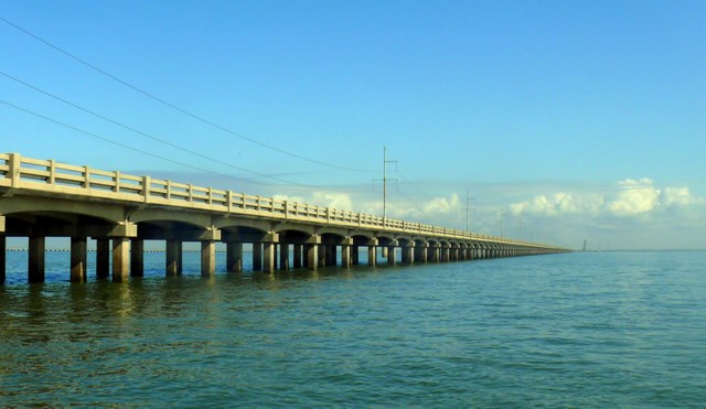
To our surprise, however, the wave action was only a moderate one foot chop and we were able to maintain thirty mph on the GPS. We headed due east and the deeper we reached into the lake the calmer the wave action became. At about ten miles from leaving the Pass behind, we abruptly broke through the fog bank and found a bright, calm lake with the Causeway stretching from north to south on the short horizon. By the time we reached the Causeway we were cruising at fifty mph and making up for lost time.
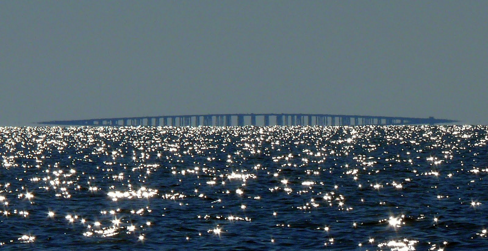
The Causeway is singularly unique: Nothing you have ever seen prepares you for the sight of this impossibly long piece of concrete spanning the water. We literally came out of a fog bank to reveal the sight of the bridge from about two miles out. We probably would have seen it earlier but the incredibly thick fog bank kept it cloaked. I turned around to see what we had just emerged from and it looked like a giant, gray mass of shaving cream plopped on the water; I would never have had the nerve to enter that thing from where we were now. We stopped under the bridge and listened to the traffic rattling overhead. From underneath, I noticed there were no ladders, handholds, or any way imaginable to climb the smooth, round concrete posts up to the span. You might as well be anywhere in the twenty-four mile bridge crossing as far as getting help. If equipped, you could anchor near the bridge, but there was not one place to even tie up. -Next time I’ll try to remember to bring my ascending gear and a grapple hook - just in case. -Shawn
Sixteen miles later we had found the I-10 bridge which runs north from NOLA to Slidell, LA and we all took a well needed bladder break. On the move again, we ran single file south by southeast as I led the way navigating through the way-points I had marked around some possible shallow water shoals. We finally dropped into Chef Pass and found our second way-point at the Chef Pass Marina.
Although the attendant at the Chef Pass Marina was unoffensive, he made no attempt at small talk regarding our adventure. As the day progressed most folks would inquire about our trek, or the PWC racks and external fuel tanks. They would either seem genuinely impressed or, at the very least, interested in our journey. The only thing the Chef Pass Marina gentleman was interested in was a Ben Franklin for the fuel we purchased. Prior to departing, I phoned the Inner Harbor Canal Locks (IHCL) and informed them of our approach to which I was given radio directions by the Lock Master. Crossing under the Hwy 90 bridge and train trestle, we exited Chef Pass and turned due west into the Gulf Intracoastal Water Way (GIWW). I don’t think one can really appreciate the amount of effort (and tax dollars) it is taking to shore up and defend our post-Katrina city of New Orleans. The north bank of the GIWW is commanded by a large dirt levee that is obviously being used to block the south shore of Lake Ponchartrain. Just before passing under the Paris Rd. bridge, I pointed out the Michoud Plant and it’s super structures to Shawn and Cody. I explained that this is the facility that builds the external fuel tanks for the Space Shuttle program and is owned by NASA. I’m not sure, but I think the fuel tank, once completed, travels by barge, via the GIWW to it’s home office in NASA, SoFL. Directly south of the Michoud Plant we got a good look at the sea wall that looks recently completed to block of the Mississippi River Gulf Outlet (MRGO, “Mister Go”, as we say in SoLA). I remember the MRGO taking a lot of blame for the Katrina storm surge, and it seems that the Army Corps of Engineers has concurred; the concrete structure is quite impressive.
Massive pieces of equipment line these waterways. Unimaginably large versions of cranes, rigs, barges, pipe, platforms, and tugboats are parked everywhere. I felt like a “Honey I Shrunk the Kids” cast member crawling through a bathtub full of heavy equipment. The media has lost interest in Katrina repairs to New Orleans, but let me report: the levees that ring the Crescent City will be at least twenty feet higher after this round of upgrades. Many places caused us to pull back to idle as we navigated around and under canal obstructions and construction zones. The ever present thought of this being America’s Venice is sharpened by the visual confirmation that there is no land more than a few feet above the water - except for that levee. Billy informed me that all of New Orleans was behind that pile of earth. I kept wondering where the enormous dump trucks were getting the dirt to build it higher. Were they just scooping it out of the bowl on the other side? -Shawn
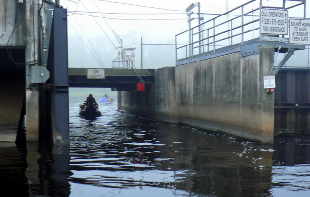
We continued due west in the GIWW and eventually met up with the Inner Harbor Canal (IHC). The IHC connects the Mississippi R. to Lake Pontchartrain, but it’s currently under construction on the north end near the lake, hence our “detour” all the way across the lake and into Chef Pass. The construction zone in the IHC added twenty-five extra miles to the route which GL and I had tried last fall. Turning south into the IHC, I hailed the Lock Master over my VHF radio and was given instructions to “standby” just south of the Claiborne Ave. bridge. We “stood by” for the better part of an hour when the lock doors finally opened and a tug and barge combo, followed by a solo tug, plied northward. A lock attendant came out from the control booth and motioned us in. That I know of, navigating through the IHCL was a first of a kind for all of us. The attendant threw down a rope for us to maintain our position while the doors closed behind us and the pumps began there job. As this was a Spring trip, the Mississippi was on the rise due to some early snow melt from up north. Our little flotilla of three PWCs was being raised eleven feet to match the water level on the south side of the locks.

I’d never actually seen a lock before. I know basically how they work, but this was the first one I’ve been through. Not impressive as a clean, oiled, well running machine, it rather resembled a forty year old dump truck - the kind that bangs it’s rear flap thing and doesn’t get to where it’s going with all the load it started. The doors of the dock were leaking water furiously when we first approached it. A gap in the gate allowed water to gush out like a waterfall from ten feet high. Eventually I realized that there was water behind the doors and they were letting a boat drop down. Duh. Like I said, I’ve never really seen a lock. After the doors opened and the lock’s current tenants made there exit, Billy led us into the steel and concrete canyon of about forty feet by 500, or so. My first impression was that there was NO way out of this thing: A completely slick, walled-in, concretel box that measured at least 30 feet from our water line to the top. I spotted a small set of steel rungs embedded into the far wall and imagined my escape plan when the whirlpool sucked my jet ski under. Of course, that didn’t happen. Some guy on top tossed us a large (30mm) rope to hold. Over the next few minutes he slowly let the rope drop down to me until I was holding about ten feet more rope than when we started. And then, the other door of the lock opened. We were required to wait for a loud blast of a horn before exiting the lock. Just beyond the exit doors was the front end of a barge looming fifteen out of the water and waiting to enter. When the signal came, we scurried around the front of the barge and then between it and the lock walls. The tug pushing the barge revved it’s engines as he timed moving into the lock at the same time we were exiting. We picked up the pace as we made our way down the barges length as I was under the impression we were going to be pinned against the lock wall. The entire “lock experience” was not like any I’ve ever really had, and for all the anxiety it turned out to be a very simple process: Just a pause in the route, then elevated up eleven feet into the Mississippi River - piece of cake. -Shawn

Flooding of the locks didn’t take long, and I never got the impression we were “elevated” as much as the wall above us just got “shorter”. The doors finally opened on the south end of the locks and upon emerging the concrete pool we had found the mightiest of rivers in all of North America.
I think entering the the big M. was a jaw-dropper for all of us: My first impression was that we had entered a very large lake with one hell of a current; the west bank was no less than half a mile away. Secondly, one found almost every type of moving water situation compacted in every square acre of water. There were converging currents, boils, rip lines, swells, huge eddies... all of it, of course, being compounded by the river traffic. In particular, there was one empty cargo ship steaming north at a steady fifteen or so knots. You could tell she was empty due to the eight feet of water piled up on top of the bulbous bow, which was just under the water’s surface. Being no less than 700 feet, stem to stern, she was putting up eight foot swells for at least a quarter mile in her rear wake.
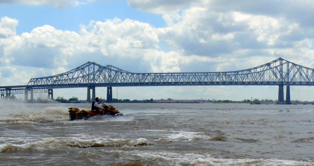
Passing really large ships and barges always make me nervous. I never remember that about two thirds of the way around the thing you always hit the bow wakes. This reality catches me in the middle of fiddling with my camera with an open glove box full of gear. Using my only available hand (left) to frantically hold the contents in place, I crash into an enormous wave going way to fast. With my right hand death-gripped on the handlebar, I get deluged by water coming over the bow. Killing the power, I’m sloshed around at the mercy of these large, violent ships which now have waves lining up one after another around my ski. I finally come to rest and am now bobbing around like a cork. That’s when I notice the moving steel mountain coming along side me. I manage to get the box closed with both hands, then, getting the ski started, I turn parallel with the ship and start wave negotiations to get past the bow. This would happen over and over through out the day as I could not quite get the hang of passing large vessels. Billy and Cody seemed expert in how they would slow up a bit, then turn into a wake or wave head on and then accelerate through them with little problem. When we encountered a large cargo ship on the Mississippi, I was, as usual a few hundred yards behind them and, as usual, I forgot about the wakes and waves the large vessels create. My newbie tactic of killing the power had left me in the midst of waves being left in the ship’s wake. The stern wake coming off the ship was easily ten feet from top to bottom. I flew off the top of the first crest, became airborne, and crashed into the bottom of the next one, planting the tip of the boat deep into the river. A six inch wall of water came over the front to blast me. Even though I was still holding my camera, I managed to grab both handlebars. Water shot up my nose, yet I managed to hang on to the ski just long enough to jet up over the second wave. Waiting for the ship to pass, I regained my composure, secured the camera in the glove box, and headed out to try and pass the beast again. This time I remember there was going to be a wake and I took a wide approach so I could turn into the forty-five degree wave he was producing. There were about fifteen mini tidal waves to ride each, requiring that you let off the gas before the top so you could glide over in zero G, then ride down the other side like a sled. The only forward progress you could make was on the up wave climb. It took a few minutes to gain on the ship as she was probably going twenty mph, herself. When I cleared the last wave it was perfectly flat water. I was about 100 feet from his bow, which was a little too close, so I powered up to fifty mph and panned the river for any sign of Billy and Cody. A quick assessment counted about twenty large things on the river, all seeming to move in different directions. There was the cargo ship just behind me, another large ship out in the river going the other direction, and two barge setups in front of me - direction undetermined. There were three, maybe four, ferries going across the river, and a paddle wheel boat blowing his horn - hopefully not at me. There were some small boats, too, going up and down river. Once again, I stopped to assess my situation: I had at least a minute on the cargo ship before he caught me again. Billy had shown me the plan a few weeks ago and I distinctively remember that we had to enter one side of the river and exit on the other. Opposite banks, opposing locks. I looked hard across the river for any sign of the two other jet skis. The cargo ship that was still up river was closing the gap between myself and the one that I had passed - I would have to move now or wait and go around the back of the second ship. The turbulence between the two where their wakes would meet would be nothing less than interesting... If I waited, I might end up being miles behind my companions, plus, I figured they did not want to stay in the middle of the river any longer than I did. Billy has the habit of blasting through tricky spots and suspending the established practice of “checking for McKee in the rear view mirror every five minutes or so.” I am thinking now that he and Cody have blasted to safety on the other side of the river. The calm water in the center of the river was beginning to change. Strange boiling water formations came up all around the ski resembling the top of a hot tub on high speed agitation. Luckily, I gave the River Walk shore one last look and that’s when I see two tiny things bobbing on the water near the tourist steps. YES! Now all I had to do was beat the barge going up river between me and them. I took off nearly full throttle with both hands gripped like the final lap of a motocross race. It took about a minute to circumnavigate the barge and fly down the near shore toward them. I was so excited that I did not realize I was going over sixty mph and when I let off I did not stop until I had shot past Billy and between him and the River Walk steps. Turning around I came in close to the pair like a lost dog in a rainstorm who just found his owner. I was greeted with “Where’ve you been?” to which I replied “How about that boat wake?” (never show fear). -Shawn
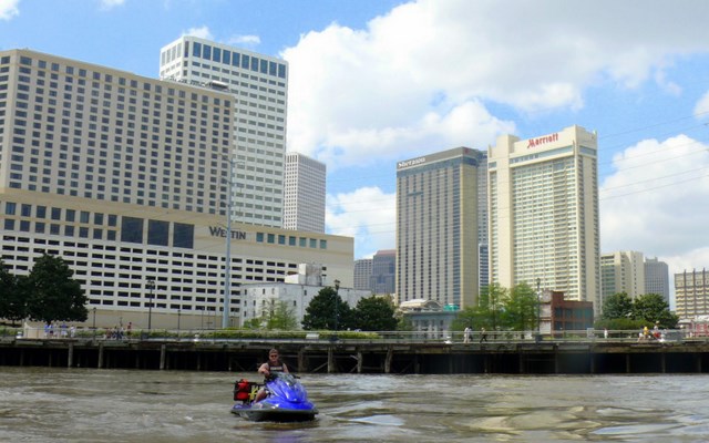
The river was full of other traffic, too: There were paddle wheelers full of tourists, crew boats, and cargo and tankers of varying degrees. It took the better part of mile to pass the empty cargo ship headed north and in doing so, we finally came to rest just in front of the River Walk which fronts the French Quarter. As the weather was very agreeable, the River Walk was full of folks enjoying the Spring air. When we came up close to the pier, you’d have thought they had never seen a PWC before. Well, at least not in the Mississippi River. It seemed many a camera and camcorders came out and all eyes were on us. I don’t know how Shawn had fallen so far back, but out of nowhere he zooms up to Cody and I, nearly avoiding a collision between us and the River Walk pier. This was about the same time the “Shawn McKee One Man PWC Show” began. Shawn began a display of runs and maneuvers for all the Who Dat’s to admire. Cody, getting my attention, nodded his head towards Mac and inquired: “I guess he’s not worried about running out of gas on this trip...?” I explained to Cody that Shawn was the only one of my friends that had not been affected by the current economic recession or the price of gasoline...
Although our intentions were to tie-up and stretch our legs on the River Walk, we agreed the river was just too rough. And, we didn’t want to get caught in the rear wake of the empty cargo ship which was nearing our position. We pushed north in the river and after a “long” six miles we had found the Harvey Canal, which was our gateway to the GIWW and all points west.
Needless to say, I hung close to the leader for the rest of the MS River stretch. I do regret not having called a friend of mine who works in a high rise in New Orleans to ask him if he had seen those three idiots out in the river today on jet skis. LOL. -Shawn
Just as we we’re approaching the Harvey canal I had noticed the aft section of a small tug entering the lock. I quickly raised the Harvey Lock Master on the VHF who replied with a simple “standby” message. After a five minute wait I told the guys to follow me right up to the the lock wall and lets see what happens. The tug and barge that had just entered was a small combo, and I was hoping we could piggyback on the westward lock. I picked up a small amount of chatter between the Lock Master and the tug captain and then, a few seconds later, the tug captain motioned us in along with the Lock Masters radio command to enter. What luck! While we had to wait nearly an hour just to enter the IHCL, the Harvey lock took less than ten minutes. We throttled the skis forward to the rear of the tug where the captain waited for us to throw him our lines.

Firmly moored to the little tug, we three “aqua-trekers” had a fine conversation with the tug’s captain. He was a very nice 27 year old that was born and raised near the lock and now lives on the Pontchartrain's North Shore. He had been working on the water all of his adult life. He inquired about our trip and we discussed the route we had taken and the way-points we were yet to navigate.
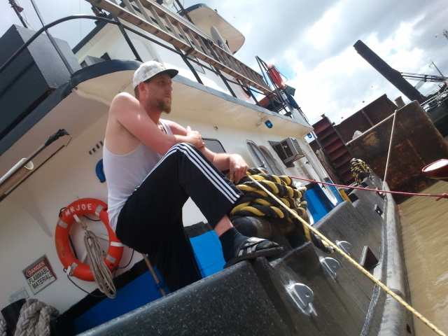
Captain Jeff Boisseau was a nice dude; although I can’t be sure, I think he told the Lock Master that he would tend to us in the lock; they don’t always allow small crafts to mix with larger vessels in the locks due to the “crush” factor. He was on the radio while were accessing into the lock, and the timing worked out great. Jeff was born and raised right were the lock is located in Marrero which is on the south side of the river in New Orleans. Well, the lock is actually in Harvey and Marrero starts about 20 feet left of the lock, he informed us. -Shawn
Giving him my camera, he captured the only picture that I show up in documenting the trip. The interior walls of the lock grew taller and the south doors finally opened. The Lock Master signaled us with his horn as the the tug captain waved us ahead of him and off we went.
A side note about the Harvey Lock: I didn’t ever bring it up, but I wondered if my companions know the significance of the Harvey Lock? The Harvey Lock is the “zero” coordinate for the entire length of the GIWW. Stretching just over 1,000 miles across the southern shores of the central United States, the GIWW runs from Carrabelle, FL to Brownsville, TX. As watercraft navigate the GIWW, they pass signs that state their location in regards to the Harvey Lock, it being the central position. So, when we would eventually pass a sign that stated “GIWW 75M WHL”, it’s to be interpreted that we were 75 miles west of the Harvey Lock.
It was not quite 1:45PM and we had put the Harvey Lock behind us. My goal had been to be between the lock doors no later than 2:PM so it was comforting to know we had made up the time lost due to the fog and sluggish L. Maurepas crossing. Easily a half hour ahead of schedule, we blasted down the Harvey Canal which is full of rusty nomenclature which belongs to the shipping, oil, and gas industries. Since it was a Friday, there were still quite a few industry related workers doing various jobs on the canal and our presence seemed to turn quite a few heads. Six miles south of the Harvey, we finally made a westward turn heading to our next fuel top-off in the bayou town of Barataria.
There was a moment of terror in the Harvey Canal where we came up on an enormous barge parked across the canal. Two thirds of the canal was used by the barge facing head first into the right bank. There was a gigantic crane on the front of the barge with twenty cables wound around pulleys from tip to gigantic hook. The crane was in the process of lifting or lowering a three story metal building that looked like it may be the crew hotel for a drilling rig. We slowed down but could not quite grasp what they were trying to do. Many dudes wearing hard hats were pointing and waving around the suspended, monolithic house. There was a second barge parked on the opposite bank leaving only about twenty feet of open water to pass between the two barges. Billy and Cody turned and shot around the back of the perpendicular barge and out of sight. I put up my camera and followed. Just as I rounded the back of the barge I realized that a monster tug boat was on the back of the barge pushing full force on the crane barge toward the right bank. In an instant I realized why the barge appeared to be slightly inclined against the far bank. This three story tugboat was pushing it into the bank so that the crane would have sufficient footing to lift the housing unit. And, the other barge parked behind the crane barge was positioned to receive the prop blast from the tugboat and spare the delicate earthen banks of the canal. In this instant of perception it all came together, and now, unavoidably, I was entering a side flowing river of prop wash behind the tug. My ski instantly shot left toward the shore protecting barge. I spun the handles and goosed the ski, narrowly avoiding the side of the parked barge where mounds of water was piling, and shot through the gap. As I slowed down and took count of what had just happened, I could see several pissed off hard hat guys waving fists. Slowly I cowered out past the lifting crew to avoid making boat waves that might affect the cranes position. Surely a little jet ski wouldn’t cause a major calamity. I watched the crane fade in the distance and noted no large explosions. Whew, gulf drilling disaster 2011 narrowly averted!
Just like the GIWW on the east bank of the big river, post-Katrina work is being done on the west bank: Having exited the Harvey Canal into the GIWW proper, we came across the GIWW’s West Closure Complex. The West Closure complex is an attempt make a giant back-flow preventer on the Harvey canal. We rode by this construction in awe of its size. The project will create huge gates on the canal that can be slammed shut when a hurricane like Katrina is approaching, preventing the deadly storm surge from backing up the Harvey canal and into the Crescent City. While the gates are closed, massive pumps will be engaged to remove rain water from the canal (and from the city), over the closed gates and back into the gulf. Sort of like bailing water out of your life raft during a rain storm. -Shawn
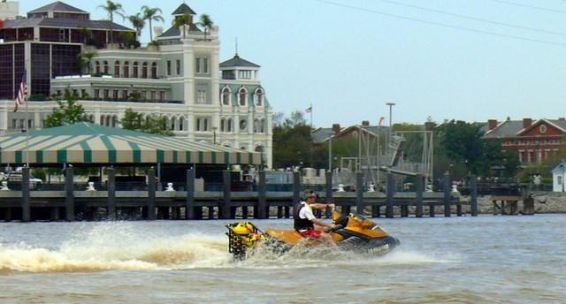
Having reached the western edge of Lake Salvador, we took a southward bearing into the Barataria Waterway. We passed through the waterside towns of Jean Lafitte and Barataria, finally arriving at Joe's’ Landing, the local marina and fuel dock. Five minutes after our arrival at Joe’s, my friend Bart DeRoches showed up in his bay boat. I had made several calls in the Harvey while waiting on the locks to drop us ten feet, and Bart, who keeps a camp north of our current location had agreed to meet us for a short lunch. Bart had made arrangements for us to overnight at his camp in the event our journey was to suffer any long delay. We shook hands all around and immediately convened inside the marina’s store for for sandwiches and soft-drinks. Bart, obviously a local to the marina, introduced us to the man, Joe, himself and we all enjoyed a break in the air conditioned and shaded room.
Without a doubt, Joe’s had the best egg and boudin white bread sandwich I’ve ever had. You have to like a place where you can pull up in your boat, get gas, get bait, eat lunch, and order a mixed drink from a full bar, all by 9:00am. And that’s what most folks were doing. Cool place. Interestingly, none of the local patrons had ever heard of coming from “the lake” down to their part of the world. Just like those on the lake had never been to Barataria by water either. We asked one guy what it was like west of here toward Houma. He said he didn’t know. All his life he had never been that far. “I guess it goes, but I can’t tell you how to get there.”
Joe Bourgeois, which is pronounced “boo-shwa”, has run the place for many years and now operates it along with his son, Sid. As in all of the fantastic gold minds of local personality we stopped, each has the standard wall photos of how bad it was when the stuff hit the fan. Usually there are photos of high water in the very room you are standing, or floating debris, and then some shots of people mopping and cleaning up after the flood. Joe explained to me how bad it was and how he lost everything - just like Pete had explained with his wall of disaster back in Pass Manchac. These little memorial corners are usually located within easy viewing distance from the best bar stool to maximize story telling. I was just plain enthralled by these stories of high water and personal triumph, although a bit naive. When I got a word into Joe’s story, I said “Katrina, huh?”. “No way, man, Katrina was nothing, it was Ike.” he said in a incredulous way that let me know I should have know better. This fact, that different water areas around New Orleans were affected by completely different storms, hammered the point that we had traversed through many water kingdoms already.

The fact that no one person at any fuel stop had been to the other stops by boat was also enlightening. Nor did Jeff, the boat captain in the lock, know how to get where we were going even though he routinely traveled across the gulf on the intracoastal waterways. -What a cool labyrinth of connecting passageways in the southern half of this waterlogged state. -Shawn
Fifteen minutes later, topped-off with fuel and feeling refreshed, we all departed the marina. Bart headed due north to his camp while we headed back to our westward track chasing the sun. At this point the GIWW becomes one lonely stretch of river and for the next eighteen miles there was virtually nothing to look at but the water, each other and more water. We LaConn riders have a saying: “Once you’ve seen one mile of the intracoastal, you’ve seen it all.”. We finally made Larose, which is a bayou side community at the intersection of the GIWW and Bayou Lafourche, but the change in scenery didn’t last but for a few miles.
It seems the entire fleet of deep drilling is in dock on this part of the GIWW. We passed at least ten ongoing sandblasting operations, complete with plastic covering the ships, billowing smoke coming from every opening, and white clothed astronauts holding sand blasting hoses. The smells of chemicals on this stretch of the trip deserve their own separate trip. Smells you are not supposed to smell “outside” were abound. It was impossible to miss the distinctive odors of magic markers, spray paint, fingernail polish remover, glass cleaner, gasoline, paint remover, and countless other unidentifiable wisps. This must be were they make those smells that go into all those products. Cool. By the way... I’m feeling goofy... -Shawn
We hit another stretch of liquid barrenness and about halfway between Larose and Houma we throttled down the bikes for another short break. I motioned Shawn over and told him he had a “cruise control” device in the PWC’s glove box that he should be utilizing for the long, flat stretches. The “device” is really nothing more than a wedge of plastic which is secured to the rider’s wrist by a short lanyard. By simply wedging the piece of plastic in the between the throttle lever and it’s base, while running, the throttle will remain open virtually giving the operator a chance at nearly hands-free operation. Shawn called dick-move on me, again, as he said I waited until mile marker 155 (out of nearly 225) to make his life a little easier... oops, my bad...
DM number three to be exact. Even though I now admire how completely he planned for this DM and took advantage of my “newbieness”; my thumb has still not recovered and I have to click the mouse with fingers only. -Occupational injury. The sweetness of this move can not be underestimated as he routinely showed off riding with no hands throughout the day, never letting me see the digit saving device he had - and knew was in my glove box. I tried to figure out how he was doing it but figured his ski had more options. Eventually I was riding with my left hand crossed over the handle bars holding the throttle while shaking the cramp out of my right hand. The dang thing has a strong spring to insure it returns to “off” when you let go. Billy finally took pity and showed me the device AT MILE 155! Looking back, I guess I’ve “rocked” him enough on cave and camping trips to deserve it. Boy, was he sure enjoying this. -Shawn
Fifteen minutes later, we finally made the east side of Houma, and this is where the current situation of the economy can be determined by a good, local eye. Like parts of the INHC, Larose, and eventually Amelia, the Houma waterways are lined with various vessels that support Louisiana’s all important oil and gas industry. Just about everywhere you could see there were supply ships, crew boats and large, ocean-going vessels. During the good times most of these vessels would be coming and going but the current moratorium on drilling in the Gulf of Mexico has most of these industry assets in a “mothball” status. Making our way out of Houma, we passed the Houma Navigational Canal on the left and headed into another long stretch of flat water where the GIWW splits the marsh for over twenty miles before arriving in Amelia. Again, we were left to our own devices of entertainment. Cody stayed in his customary position of starboard wing-man, while Shawn either lagged behind in my wake, sometimes on my port, or sometimes, while playing with his GoPro HD camera, doing a flyby for film capture.

As stated before, a person only needs to see one mile of marsh bank to have seen it all. I tried to whistle but we were moving to fast, so I decided I’d take a nap. I had the “cruise control” set and took a good, long look at ten miles of emptiness in front of us. Nudging up close to the yoke, I draped myself around the steering column and laid my head down. I never actually nodded off, but I’d close my eyes that were shielded by goggles and would just peek over to my right at Cody every mile or so.
This part was interesting in a way to me. We came across fields of cattle grazing right to the edge of the canal. Low trees allowed views at times for miles in either directions past the canal. Many ships of all sort were trudging by in both directions. Occasionally the odd oil derrick part or floating steel something would appear, being towed or pushed by another boat. -Shawn
I continued in this fashion until we reached the area of the marsh that my father had introduced me to while bass fishing: We ran between the north and south canals of the Orange Grove, across Lake Hackberry and flew by Copasaw Bayou. I wondered if any of this area felt familiar to Shawn as he had traversed the area with me on two prior PWC outtings. We reached the south end of the Shell Cuts and pulled over to get out the GIWW’s current and discussed the fuel situation. Heading into the Shell Cuts would take us to my final way-pointed fuel stop, but it being past 4:30PM on a Friday, I figured the Bayou Black Marina to be closed. Although our cluster’s were reading below a quarter of a tank of fuel remaining, we were each still carrying ten gallons in the external tanks. We continued up the GIWW and reached the intermediate area of the GIWW’s “wiggles”. Here the waterway goes from an engineered man-made canal to a large meandering bayou. The terrain, too, changes. The open marsh disappears and large, second growth cypress trees begin to line the banks.
At this point we encountered yet another change of scenery - the only common trait being the water. Here, the most beautiful part of the trip, to me, begins. The first time I saw the Atchafalaya basin or “the spillway” as they call it in Louisiana, I was blown away. It is truly a national treasure. Why it is not a national park I can only guess. This piece of perpetually flooded land in the middle of southern Louisiana is every Americans prized inheritance. At age eight, my uncle explained to me how the Mississippi river makes this left turn near where the river ceases being a border between the states of LA and MS. At this point, the Mississippi becomes a Louisiana river only. This is also the same area where the river is trying to go west, then south, down the old path known as the Atchafalaya River. The US Army Corps of Engineers, using the Old River Control Structure, divert and manage how much water goes where. “We can stop it”, my uncle would tell me, “but are only postponing the inevitable change in course that the river will take. Right now we “allow” about one third of the mighty river to flow through the locks and down the Atchafalaya river. It’s a short term deal with the Mighty river. This hearty amount of fresh water seeps all the way due south, behind Baton Rouge, to the gulf. Because we (man) have never levee’d off this flow into a ditch, like we did on the Mississippi, the river water spreads wide and far creating a natural wonder of aquatic life.” Stop right there. -That sounds downright cheesy, but dang, you have to see it to believe it. It is awesome and breathtaking in its seemingly untouched and natural swampieness. Its overwhelmingly Grand Canyon-like inspiring in its vastness. And it is vast, trust me. Very few native “spillway” fisherman have ever even been to its outer extremes, must less know how to get there. I love this piece of North America. -Shawn
We had no sooner passed Bay Wallace when my low fuel buzzer started talking. I leaned to port and motioned Shawn to my side where he too acknowledged a low fuel warning. Although he was also on the low end of the tank, Cody was still in good shape as his Yammi holds an extra two gallons in the internal tank. Reaching Amelia we turned north into the local Intracoastal Waterway (ICW)and left the GIWW behind us. We headed due north in the ICW and quickly made the Amelia ramp located just underneath the Hwy 182 bridge. Having emptied our external tanks, we got back on our northerly bearing in the ICW and headed towards the Belle. Turning into Belle River, we let the ponies loose and raced for Gros’ Marina. Cruising down the river at a 60 mph clip I noticed that the trees on the west bank had cast their shadows nearly to the east side of the river - where had the time gone? Reaching Persimmon Pass, we turned right and trekked across the open waters of Grassy Lake. Finding Four Mile Bayou on the east side of Grassy Lake, we headed up the lazy bayou and finally made landfall at Gros’ Marina.
Ah yes, Gros’, another water accessed establishment with boiled crawfish, beer, daiquiris, mixed drinks, karaoke, and gas. This was familiar ground for me -finally. Gros’ is also the staging ground for the annual Green Hulk’s Mugbug PWC rally and not too far from Billy’s camp. I could sense we were close to finishing this trip. -Shawn
Upon mooring the bikes, we were immediately greeted by Chuck Germany and Alex Baker, both being Green Hulk members that were down for “Mini Mudbug”. Mini Mudbug was a scheduled group ride for Saturday that quite a few out-of-staters had come in for. I made my final check in with Mike letting him know that we’d arrived without incident and that he was now off the hook for getting us out of trouble. Grabbing a few drinks from inside the bar, we all sat down and the story telling of our journey began - Shawn commented that the stories had become embellished as the day got later and by Saturday, when he was back home, the stories would be outright lies... (OK, only the ones about Shawn, right?) At about 6:45PM, with the sun in place over the western horizon, we mounted our bikes for the final leg of one fine, long ride. Alex and Chuck escorted us to the south end of Lake Verret where upon we parted ways.
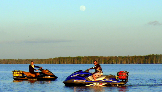
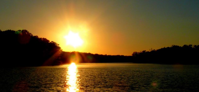
I took a brief moment to pose Cody and Shawn in the lake’s south end: The moon, making it’s closest approach to the Earth for the year, was full and bright, and in perfect opposition to the setting sun. After the moment was recorded, we throttled the bikes down Bayou Magazile and hooked back up with the Belle.
Fifteen minutes later, having arrived at the camp, the sun had made it’s way beyond the horizon and we shut down our engines for the last time. While we had battled some elements during the beginning of our journey, we managed to complete a truly magnificent trip.
Consider the math to accomplish this trip by PWC in a single day: Factor in about a 50% chance of having good weather, then add in the chance for mechanical problems, navigational errors, locks taking hours to get through, someone getting sick... it really is amazing that we were able to complete this trip. It was only Billy’s second try. I felt like this would be a nice ride but we would be turning back or aborting for shelter before reaching the end. These amazing boats are perfectly made for this type of water exploration. Billy’s skis go 65mph and Cody’s goes 80+. When the water is smooth you can really make up time. Contrastingly, when the water is rough you can slow to as low at ten mph and forget about covering the miles on a trip like this one. Billy’s expert modifications that allow for two full, five-gallon tanks to ride on the back of a PVC pipe-made rack are the technical keys to this trip. Without this we would have run dry in Amelia. Knowing the route cannot be under appreciated either: Billy not only expertly mapped and loaded the entire route using google earth and his mounted GPS, but he called a dozen or so places on the route to confirm fuel, boat traffic, hours of operation, weather, and lock protocol. There’s an old saying in mountain climbing that the climb is only one tenth of the work it takes to reach the top. Billy probably confirmed this ratio with the amount of time he put into preparing for it over the past three years. He deserves all the credit for the success of this trip. Nice work. -Shawn
Although this trip has been done by larger vessels, I have been lobbying the fact that this was perhaps the first time it had been done in a single day by PWC. So, by the numbers, what exactly did we do? Our single day of riding encompassed the following:
- The completed track looked like an “ugly horseshoe” as the beginning and end of the trail are only 33 miles apart (as the crow flies).
- 223 miles of travel, of which only 4.5 miles were “common” miles (Barataria Waterway).
- Circumnavigated 2815 square miles of South Louisiana.
- Total navigation time of 11 hours and 43 minutes.
- Approximate moving time of 8 hours and 38 minutes, for an average speed of 26.5mph.
- Approximate fuel consumption of 45 gallons for an average of 5mpg.
- Navigated 6 miles of the Mississippi River.
- Elevated 11 feet in the Inner Harbor Lock, but lowered 10 feet in the Harvey Lock (Where did the 1 foot difference go? LOL)
- Travelled through 20% of the total parishes in LA: Ascension, Livingston, St. John the Baptist, Tangipahoa, St. Tammany, Orleans, Plaquemines, Jefferson, Lafourche, Terrebonne, St. Mary, St. Martin and Assumption.
The End - Lets go ride...
No comments:
Post a Comment